Australia: Half the nation to be drenched as peak of a massive wet weather front hits
Residents from the deep reaches of the outback to the coast are being warned to brace themselves for the peak of a mammoth rain event that will drench almost half the nation today and tomorrow.
Authorities are urging residents across multiple states and territories to keep an eye out for warnings in their areas and take extra precautions.
They say the risk of riverine and flash flooding are likely in many areas as conditions worsen today.
The “significant rain event” began yesterday for many parts of the nation — with parts of Central Australia being hit by the highest rainfall totals in years.
“We’ve already seen November records smashed for daily and monthly rainfall across Australia’s Red Centre,” Alison Osborne, a meteorologist for Sky News Weather said.
She said the event will significantly worsen in the coming hours, with the “peak” of the system to hit today.
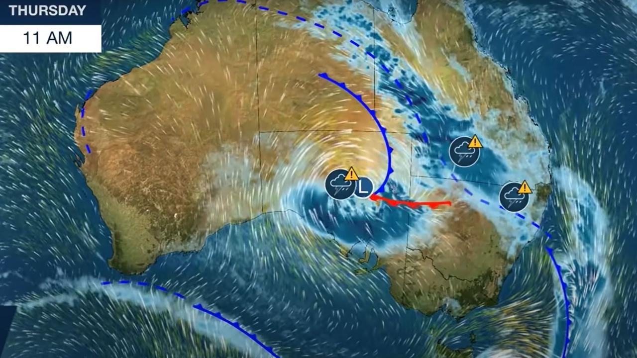
Starting from the south of the nation, Ms Osborne said one part of the massive wet front will bring heavy rainfall and damaging winds for parts of western and central South Australia, before it “steamrolls” eastwards over Victoria tonight.
However, she said that today the biggest risk is for Queensland and northern NSW — where she said, by the afternoon, there will be “widespread rain, intense rainfall rates, thunderstorms delivering locally heavy falls, flash flooding and rivers rising”.
By tonight, that big band of rain will push over almost the entire Queensland coastline, and deep into inland areas too, and stretch all the way down to NSW’s Central Coast.
Later tonight that band will move over the southeast bringing heavy rainfall to many areas across NSW including Sydney.
And from Friday it will be Victoria that cops it the hardest as the front moves back in off the Tasman and lashes almost the entire state with heavy rainfall — with particular concern for flooding in the Gippsland area
Late-night alert warns weather will ‘worsen’
The Bureau of Meteorology (BOM) has issued a late-night alert warning residents in NSW and Qld that heavy rain and flooding is only set to get worse over the next 24 hours.
“Conditions are expected to worsen tomorrow & could cause dangerous flash flooding & riverine flooding,” the Bureau warned.
It said that “phenomenal rainfall” has descended over several parts of Australia.
“Life threatening” flooding is highly likely, the BOM warned.
On Wednesday, Alice Springs recorded over 100mm of rain, its wettest day in 20 years. Samuel Hill, north of Rockhampton in Queensland, recorded 341mm of rain.
“Multiple states and territories are now under rain warnings and flood watches as wet and stormy weather grips large parts of Australia over the past 24 hours. We’ve already seen phenomenal rainfall,” said Bureau meteorologist Jonathan How on Wednesday.
Severe weather warnings for heavy rainfall are in place for much of South Australia, inland northern NSW and the Riverina and southern Queensland’s Darling Downs and Granite Belt. The areas covered by the warnings could grow.
Life threatening conditions
Authorities have urged residents in flood prone regions to put plans in place in case they need to evacuate.
“In addition, thunderstorm warnings will be issued in coming days and some storms may have the potential to produce life threatening flash flooding and damaging to destructive winds,” said Mr How.
“Expected rain will lead to riverine flooding and flood watches are current for the interior and towards the coast.”
A heavy band of rain — which is predicted to bring a month’s worth of rain in just a couple of days — has already begun soaking large parts of Queensland and NSW.
The Bureau said the worst of it will be on Thursday and into early Friday and that communities in the northern reaches of NSW will be some of the worst affected areas.
A cold front will move in once the rain clears on Saturday, which could potentially mean snow falls for low-lying regions to the south of the state.
The SES has urged people to think carefully before taking to the roads and for those in the hardest-hit areas to “be prepared” for flooding.
Earlier on Wednesday, BOM senior meteorologist Jane Golding said the massive wet front was being caused by a tropical air mass being driven by warm waters in Indonesia and Northern Australia.
“At the same time we’re seeing a very deep low pressure system over South Australia that’s tracking towards NSW,” she said.
“The combination of these two systems will bring wet and stormy weather to NSW and we’re expecting some very intense rainfall in some areas and potentially some very cold air to follow it.”
Beginning today and carrying on until Saturday the rain in NSW will be “very heavy” at times and, because soils in many areas are already saturated from a wetter than average spring, it is likely to cause flooding.
“We’re expecting this rain to bring riverine flooding, but also some dangerous flash flooding and road flooding,” she said.
She said many areas in the state will see more than 150-200mm of rain in the next few days — with the hardest hit areas predicted to be around the Queensland border. The bureau says “major flooding” is possible around the north west and south west slopes.
“But storms more generally will be a feature across the state, so those dangerous flash flooding type rainfall rates could be seen across many areas,” she said.
“We are looking at a wet and stormy second half to this week. We’re already starting to see the rainfall and we’re expecting that rainfall to increase. Record-breaking rain is likely for some locations.”
Ms Golding added that rainfall records are already being broken by the wet front, with some areas seeing their highest rainfall totals in 10 years.
“Broadly, across NSW many locations will exceed what they usually see in November,” she said. “So it’s a month’s worth of rain in just a few days.”
Assistant Commissioner Dean Storey from the NSW State Emergency Service said some 10,000 members were on standby to respond to the “significant rain event”.
“The message is be aware and be prepared,” he said. “The SES along with our partner emergency service agencies are in a heightened state of readiness. If you live in a flood-prone area, know that risk and plan accordingly.”
He warned that roads across the state may be flooded and cut off.
“Avoid unnecessary travel, stay off the roads if you don’t need to be there, know your local risk and don’t drive into flood-affected areas,” he said.
He said it will be the biggest flooding risk since the major floods back in March.
The good news is that the BOM predicts the heavy rain should clear up by Saturday morning, but it may be followed up cold air and strong winds — which could potentially mean snow falls for low-lying regions to the south of NSW.
Source: news.com.au