Thousands of hectares burned in famed national park, Lesvos

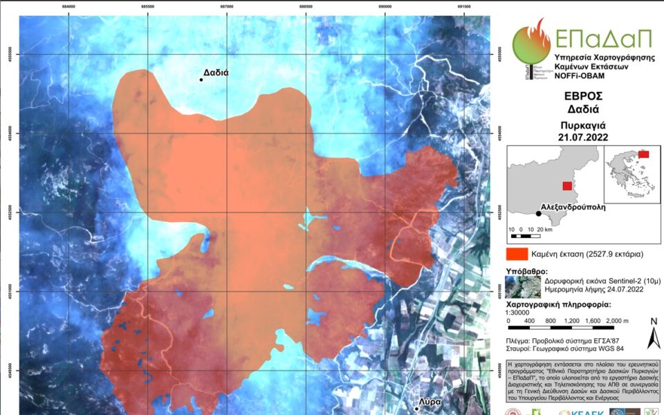
Over 2,528 hectares of dense woodland have been burnt so far in Greece’s most important protected habitat, in the northeastern region of Evros, as the blaze continued to rage for a fifth day.
The information was illustrated in maps created by the National Observatory of Forest Fires (NOFFi), which were released on Monday and displayed the extent of the damage to the Dadia-Lefkimi-Soufli National Park.
According to reports, the wildfire has caused a serious ecological disaster to the national park, which is home to hundreds of plant and animal species, some of them rare.
NOFFi-ΟΒΑΜ also said that over 1,709 hectares had been incinerated in the area of Vatera, on the eastern Aegean island of Lesvos.
An assessment of the fire on Penteli mountain near Athens will be provided later, it said, with preliminary figures hinting at a destruction of 2,430 hectares.
The maps are based on preliminary analysis of satellite images, expected to be updated with images from satellite Sentinel-2 when the fires have been extinguished. They will be used by agencies, ministries, the Aristotelian University of Thessaloniki, and the Interbalkan Environmental Center (working with the EU and UN agencies) in plans for restoration of the forestland.
Professor of Forestry and Natural Environment Ioannis Gitas, who is also director of the University of Thessaloniki’s Laboratory of Forest Management and Remote-Sensing, told state-run news agency AMNA that there were more fires in Greece this July compared to 2021, while the heatwaves have also occurred earlier than last year.
Source: AMNA


